Botanical Surveys
Phase 1 Habitat survey
This is a common and standard form of survey, typically complementing other forms of survey, aimed at identifying broad habitat communities and key plant species. Where applicable, it also includes information relating to important features on the site, for example, the presence of a of a rare or notable species or habitat. Botanical surveys can be undertaken throughout the year although spring or summer is the optimum period. Maps are all digitised using our in house GIS system.
NVC (National Vegetation Survey)
This is a more detailed and systematic survey providing plant composition and abundance data used to determine known semi-natural habitats that occur throughout the British Isles. It is often used at sites of known conservation significance.
Hedgerow surveys
These surveys are undertaken in accordance with the Hedgerow Regulations (1997) and are typically required when a hedgerow removal notice is submitted.
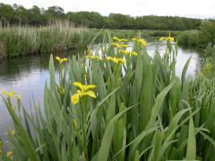
River corridor survey
This survey identifies important features of the river and can be useful when determining the impact of a scheme, such as culverting, along a watercourse.
Invasive weed surveys
There are a number of vigorously invasive weeds such as Japanese Knotweed that can be enormously problematic. A survey for these weeds will identify the extent of the problem, enabling us to provide recommendations for the control and complete eradication of these plants.
Other surveys
- Surveys of specialists groups including bryophytes, lichens and invertebrates - WWC has undertaken numerous surveys for locally and nationally important species.
- Pond surveys using PSYM (Predictive System for Multimetrics) methodology where appropriate.